PBOT's Modal Advisory Committees are being presented with a memo (a big PDF) that includes information about areas where bike designations in the Bicycle Plan for 2030 overlap with freight designations from the Freight Master Plan. One of the overlap areas is on N Interstate Ave and N Greeley Ave (a key feeder into Interstate for bike traffic, including for me) and it includes the following excerpts (my comments in italics).
The way they describe Major City Bikeways is:
Major City Bikeways (from the Bicycle Plan for 2030).
Major City Bikeways form the backbone of the city’s bikeway network and are intended to serve high volumes of bicycle traffic and provide direct, seamless, efficient travel across and between transportation districts.
[Per the Bicycle Plan for 2030 basically puts the Interstate section as]: "motor vehicle lanes and on-street parking may be removed on City Bikeways to provide needed width for separated-in-roadway facilities where compatible with adjacent land uses and only after taking into consideration the essential movement of all modes (per the 2030 Bike Plan)"
Land Use. Major City Bikeways should support 2040 land use types.
Improvements. Major City Bikeways should be designed to accommodate large volumes of bicyclists, to maximize their comfort and to minimize delays by emphasizing1 the movement of bicycles. Motor vehicle lanes and on-street parking may be removed on Major City Bikeways to provide needed width for separated-in-roadway facilities where compatible with adjacent land uses and only after taking into consideration the essential movement of all modes. Off-street paths designated as Major City Bikeways should have separate tracks for bicycles and pedestrians where practical.
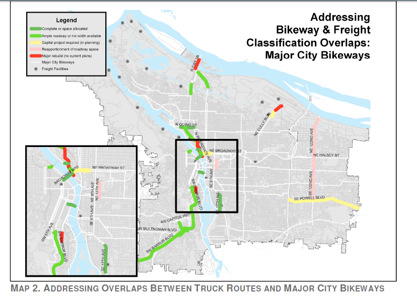
"Per the discussion, the workgroup decided to support and recommend that all bike facilities on identified truck routes have separated facilities where possible. Table 2 shows that this goal is achievable for all of the identified overlaps."
The map legend for red is "Major rebuilt: no current plans".
They describe in three segments (N Greeley to N Interstate, N Interstate to Tillamoook and N Interstate South of Tillamook):
N Greeley Ave / (N Going to Interstate)
Curb-to-curb width / ROW - 52’ / 70’
Solution: Existing bicycle lanes. Lanes could be raised or bicycle
lane width could be reassigned on east side of roadway for off-street path.
N Interstate Ave / (N Greeley Ave to N Tillamook)
Curb-to-curb width / ROW - na
Requires complete rebuild of roadway in constrained environment
N Interstate Ave / (N Tillamook St to N Thurnderbird)
Curb-to-curb width / ROW - na
Existing bicycle lanes in this section. Would require complete rebuild of roadway in constrained environment to improve.
Major City Bikeways (from the Bicycle Plan for 2030).
Major City Bikeways form the backbone of the city’s bikeway network and are intended to serve high volumes of bicycle traffic and provide direct, seamless, efficient travel across and between transportation districts.
[Per the Bicycle Plan for 2030 basically puts the Interstate section as]: "motor vehicle lanes and on-street parking may be removed on City Bikeways to provide needed width for separated-in-roadway facilities where compatible with adjacent land uses and only after taking into consideration the essential movement of all modes (per the 2030 Bike Plan)"
Land Use. Major City Bikeways should support 2040 land use types.
Improvements. Major City Bikeways should be designed to accommodate large volumes of bicyclists, to maximize their comfort and to minimize delays by emphasizing1 the movement of bicycles. Motor vehicle lanes and on-street parking may be removed on Major City Bikeways to provide needed width for separated-in-roadway facilities where compatible with adjacent land uses and only after taking into consideration the essential movement of all modes. Off-street paths designated as Major City Bikeways should have separate tracks for bicycles and pedestrians where practical.
"Per the discussion, the workgroup decided to support and recommend that all bike facilities on identified truck routes have separated facilities where possible. Table 2 shows that this goal is achievable for all of the identified overlaps."
The map legend for red is "Major rebuilt: no current plans".
They describe in three segments (N Greeley to N Interstate, N Interstate to Tillamoook and N Interstate South of Tillamook):
N Greeley Ave / (N Going to Interstate)
Curb-to-curb width / ROW - 52’ / 70’
Solution: Existing bicycle lanes. Lanes could be raised or bicycle
lane width could be reassigned on east side of roadway for off-street path.
N Interstate Ave / (N Greeley Ave to N Tillamook)
Curb-to-curb width / ROW - na
Requires complete rebuild of roadway in constrained environment
N Interstate Ave / (N Tillamook St to N Thurnderbird)
Curb-to-curb width / ROW - na
Existing bicycle lanes in this section. Would require complete rebuild of roadway in constrained environment to improve.
 RSS Feed